
MEetups
Flash Foxy Trad Fest • MAMMOTH LAKES • Sept 12-14, 2025
presented by Patagonia with support from Mammoth Lakes Tourism
Schedule is always subject to change. All programs run rain-or-shine. No refunds.
-
If you've registered for Trad Fest you're all set! Meetups are FREE and are included with your festival pass. No registration required, just show up!
-
All location listings are tentative and subject to change day-of. If you have an accessibility concern related to venue locations please email events@flashfoxy.com and we can put you in touch with the meetup organizers!
-
Climbing gear is NOT provided for meetups. Meetup leaders and participants are required to supply their own climbing gear. Groups will discuss gear needs at the festival venue prior to meetup departure.
There will be climbing harness, shoe and helmet demos available on SATURDAY for festival participants.
-
Meetups are not guided or instructional in nature. They are opportunities for participants to meet each other and find new friends to climb with. Meetup leaders will be familiar with local climbing. We encourage all participants and meetup leaders to make informed risk decisions and have conversations about risk and experience with all new climbing partners. Remember, climbing is inherently dangerous and you are responsible for your own safety.
Meetup SCHEDULE
-
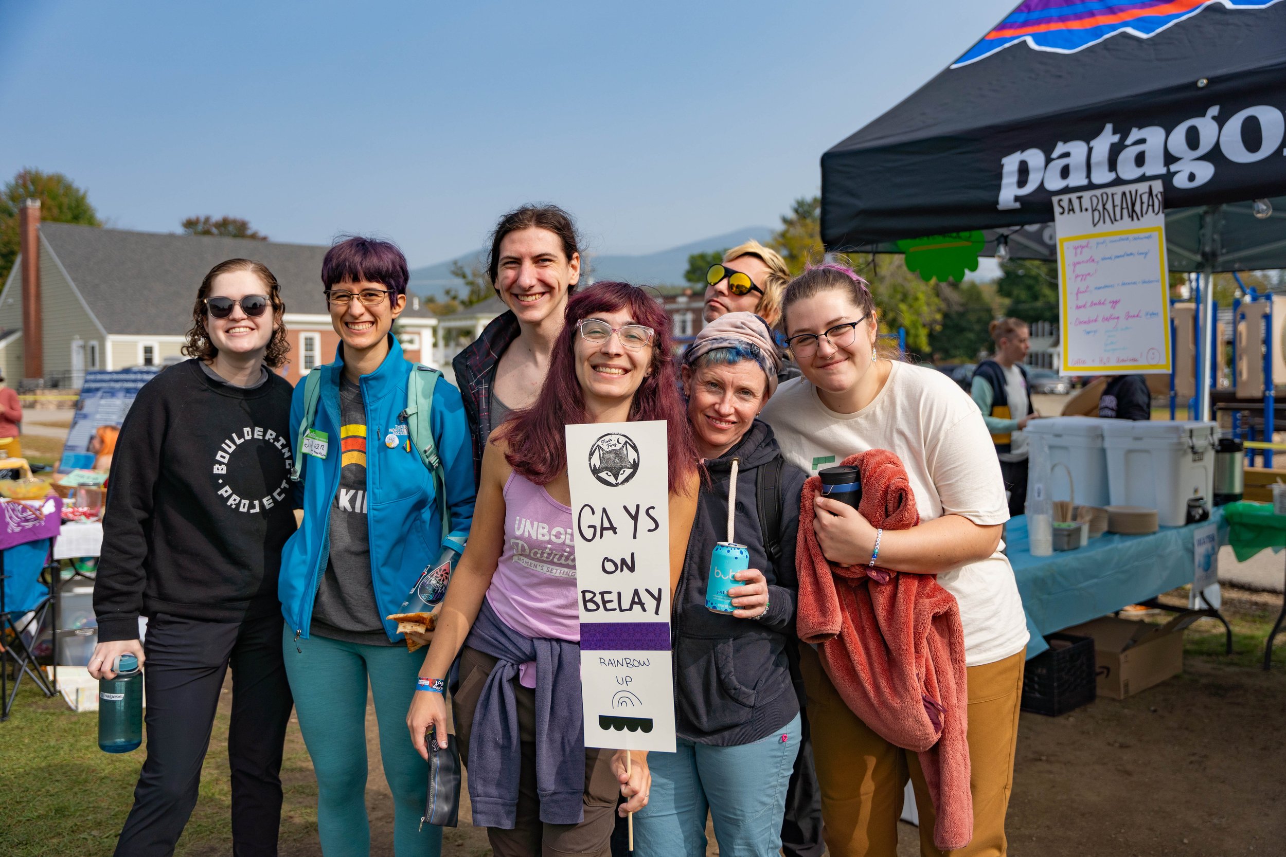
Climbing Through The Apocalypse with Queer Crush
ASL Climbing Meetup
-
Climber for Palestine Meetup
5.Fun with Eastside Student Center & Eastern Sierra Climbers of Color
Trans Sending & Trying Hard
Eastern Sierra Pride Meetup
-
Sunday Sendoff with Wall Dolls
Bouldering with MoBiBo (Moderate Bishop Bouldering)

Friday 9/12 Climber Coffee Meetup
Climbing through the apocalypse with Queer Crush
Come climb with the Queer Crush community and share coping strategies around how climbing and anything else supports you in facing what is happening in the world right now.
Friday 9/12 Climber Coffee Meetup
ASL Climbing Network present the ASL Climbing Meetup! Discover and apply climbing skills and communication strategies for an inclusive outdoor experience that benefits everyone! Deaf, Hard-Of-Hearing, and Hearing are all invited. All levels of climbers and signers are welcome! ASLize the climbing experience!
ASL climbing Meetup

Saturday 9/13 Community Partner Meetup
Details coming soon, thanks for your patience <3
Climbers for Palestine
Saturday 9/13 Community Partner Meetup
The East Side Student Center and Eastern Sierra Climbers of Color will be headed to Pine Creek Canyon for some chill top rope laps equipped with local beta, arts n' craft supplies, and the everyone-is-welcome attitude that makes the Eastside Student Center the most fun after-school center in Bishop!
5.FUN meetup
Saturday 9/13 Community Partner Meetup
Trans sending and tryin’ trad
Trans Senders ABQ and TVOP are getting together for beginer top roping and acessible trad routes at the Iris Slab in Rock Creek Canyon. Trans, non-binary, and ally climbers welcome.

Saturday 9/13 Community Partner Meetup
Eastern Sierra Pride
Whether it's your first time here and don't know where to start or you're looking to meet new climbing partners, come climb with the local queers of Bishop.

Sunday 9/14 Community Partner Meetup
Sunday Sendoff with Wall Dolls!
After a weekend of trying hard climbs and giving back to the land, we’re going to either do some big sends at Clark Canyon or take it easy at Horseshoe Lake with some laid back slab and swimming. We haven’t decided yet! Either way, we’re going to take up space and have one last hurrah with all the new friends we’ve made over the weekend.

Sunday 9/14 Community Partner Meetup
MoBiBo at The Dog Boulder
Join local meetup leaders from MoBiBo (Moderate Bishop Bouldering) for a V-fun bouldering sesh at the Dog Boulder in Mammoth! MoBiBo is a place to create a community of moderate level bouldering friends and the people who support them. All levels are welcome!

Climbing Areas
The Eastside offers plentiful options for trad climbing, sport climbing, and bouldering year-round! Here are a few crag ideas to get you started - all located within a 1-hour drive from our festival venue. Remember, all climbers are responsible for managing their own risk. Trail conditions may vary and Flash Foxy cannot guarantee accessibility of any climbing areas. Please read all parking and land use regulations carefully. Participants are responsible for paying day use fees and obtaining any necessary climbing permits.
-
Google Maps: Lake George Parking *16-minute drive from our festival venue!
The Lake George Recreation Area trailhead gives access to some of the best climbing in the Lakes Basin. Dike Wall and Horseshoe Piles have a great collection of single pitch sport climbs in the 5.8-5.12 range while Crystal Crag has climbs ranging from short sport routes to multi-pitch alpine excursions. In addition there are a number of newer sport areas that will keep you busy for some time.
Distance + Directions: From the town of Mammoth Lakes head south west along Lake Mary Road. As the road winds up into the lakes basin look for a left turn at Pokonobe Marina. Follow this left turn through a campground and over a bridge. After crossing the bridge take a right and continue to the trailhead parking.
Approach + Trail Surface: mild-moderate uphill on packed dirt/sand/gravel mix
-
Google Maps: Horseshoe Lake Parking *20-minute drive from our festival venue!
This quiet alpine lake setting above the town of Mammoth features sport and trad climbing at 10,300 feet in elevation. Plenty of climbs from 5.8 - 5.12, with top access anchors. This point is visible from many places around Mammoth.
Distance + Directions: 25 minute drive from the Mammoth Lakes Welcome Center. Take highway 203 towards Lake Mary. Follow the road (past the Lake Mary turnoff) to a large parking area at the end near Horseshoe Lake.
Approach + Trail Surface: ~40-60 minutes of hiking. Terrain can be steep and technical over talus, boulders, and packed dirt/sand/gravel mix.
-
Google Maps: Rock Creek *25-minute drive from our festival venue!
Rock Creek features sport climbing, trad climbing, and bouldering on incredible Sierra granite at around 7,500 feet in elevation.
Distance + Directions: 20 minute drive from the Mammoth Lakes Welcome Center. Take the 395 South from Mammoth Lakes to Tom’s Place. Take this road south into the canyon and the formations will appear on the west side of the canyon.
Approach + Trail Surface: moderate-steep uphill 0.2-1.5 miles on trails and talus.Trails between climbing areas are on mixed terrain including talus, boulders, packed sand and soft sand.
-
Google Maps: Tioga Road Parking *35-minute drive from our festival venue!
This area is situated at the northern end of the Sierra Eastside, and is unique in its nature given that it has some of the most easily accessible sport, trad, bouldering, and ice climbing on cliffs that are more often than not empty. Perhaps climbers are too eager to get to the better known climbs in Tuolumne Meadows, but make no mistake the climbing to be found west from Lee Vining along the Tioga Pass is worth a visit or two.
Distance + Directions: From the US 395 take the CA120 west toward Tioga Pass and Yosemite National Park to reach all the climbing. All the areas are located in a 10 mille stretch West of the 395/120 junction.
Approach + Trail Surface: moderate-steep talus downhill to crag. Some areas require a rappel to approach.
-
Google Maps: Pine Creek Canyon *45-minute drive from our festival venue!
Pine Creek lies in a stunningly scenic granite canyon nestled between Mount Tom & the Wheeler Crest. This once backwater area has now grown into a truly world class destination. Pine Creek now features over 630 routes including long multi-pitch affairs, plentiful traditional climbs, and one of the largest collections of sport climbs in the state!
Distance + Directions: Take Hwy. 395 North from Bishop to Pine Creek Road. Turn left onto Pine Creek Road. Continue through the town of Rovana and several switchbacks until you see Sheelite Canyon (the obvious deep canyon) on your right. Just across from the Campground, take a dirt road and park in one of two parking areas. Walk up the road and into the canyon.
Approach + Trail Surface: Approaches vary in length. Roadside climbing is available. Trails include narrow, sandy approaches, talus fields, and creek crossings.
-
Google Maps: Sherwin Plateau*35-minute drive from our festival venue!
Sherwin Plateau offers a selection of isolated bouldering venues overlooking the gorge. You’ll find pocketed volcanic tuff on good quality rock reminiscent of the Happy Boulders at about 7,000 feet in elevation.
Distance + Directions: 25 minute drive from the Mammoth Lakes Welcome Center. Take the 395 South from Mammoth Lakes to Tom’s Place. Turn left onto Owens Gorge road and continue for 1.5 miles and take a right at the three-way fork. Keep left on the next two forks until merging with Forest RD 4S116. Continue for a mile and park.
Approach + Trail Surface: Approaches vary, but everything is close. Expect mixed terrain including talus, boulders, packed sand and soft sand.
-
Google Maps: Casa Diablo Mountain *45-minutes from our festival venue!
Casa Diablo Mountain offers sport climbing and bouldering on quartz monzonite granite with views of the White Mountains, Glass Mountains, and Sierra Nevada Mountains at 7,400 feet. This area features many moderate rock climbs ranging from 5.6-5.12. Half of the climbs are north facing, while the other half are south facing, which makes for a great choice on both warmer and cooler days.
Distance + Directions: 45 minute drive from the Mammoth Lakes Welcome Center. Take the 395 south for 5.5 miles before making a left on Benton Crossing road. Drive 18 miles and turn right on a dirt road (3S02). Keep left at the first T (still 3S02) and stay right at the second T (still 3S02), for a total of 5.4 miles. Turn left between two trees on Forest Road 04S132C. Continue on a washboard road, make a left onto 04S132F and park in a small rounded parking area. A few climbs are visible from the parking zone.
Approach + Trail Surface: short approach! A few minutes of hiking over boulders, and packed dirt/sand/gravel mix.
-
Google Maps: Yosemite National Park *1-hour drive from our festival venue!
Tuolumne Meadows is the high country climbing area of Yosemite National Park. The region is highlighted by many beautiful granite domes which offer the ultimate in knob and slab climbing. There are also classic non-dome formations like Cathedral Peak (first ascent by John Muir in the 1800's) and the Matthes Crest which are very popular with climbers. Tuolumne Meadows is a beautiful, serene place without many of the tourist popularity issues plaguing Yosemite Valley these days.
Distance + Directions: Tuolumne Meadows is accessed via highway 120 via Tioga Pass from the east.
Approach + Trail Surface: Approaches vary in length. Roadside climbing is available. Trails include steep dirt trails, scrambling, creek crossings, and talus fields.